Ian Mactavish Report
Open Public Urban Spaces (OPUS 2008), Stavanger, Norway
Travel Log, Berlin and Rotterdam: August 2008
 |
As one of the winners of the 2008 Berkeley Travel Fellowship, I had the chance to attend the Open Public Urban Spaces (OPUS 2008) conference held at the University of Stavanger in Stavanger, Norway on the 26th of June. As I had just received my diploma and was actively dreading my splash into the post-collegiate working world, I decided that I should stretch the trip out a bit and hit a few more European cities before attending the conference. I did just that, visiting Rotterdam, Amsterdam, and Berlin. At the tail end of my trip I made a quick jaunt into Stavanger, flying from Schiphol Airport (Amsterdam) to Sola Airport (Stavanger). I only stayed in Stavanger for two nights to attend the conference, but did my best to pack those days with a full itinerary outside of the already busy conference schedule. Although my visit to the Norwegian Petroleum Museum, Kjeragbolten (Pulpit Rock), and attendance at the 2008 OPUS conference were enlightening, my time spent in Rotterdam and Berlin stands as the most thought provoking and inspiring, and speaks to the nature of this year’s theme of Architecture as a social art.
Before my trip, I had been slowly making my way through Mike Davis’ Dead Cities, and it was his description of Rotterdam and Berlin that called me to these cities. Besides having received rave reviews about these two cities from anyone who has ever been, I wanted to see how and to what extent these cities have been rebuilt and reworked after having effectively been wiped off of the face of the map during World War II. During the course of my trip I kept an active log of where I went and when– who I met and what I ate. But rather than recount in a play-by-play fashion all of the details of my trip, I have chosen to describe in some level of detail two particular observations that I had while in Rotterdam and Berlin, and describe briefly an issue that I have been trying wrap my mind around since returning from Europe, namely, how can a major city rebuild and work to promote social interaction after massive destruction?
Observation 1: Train from Amsterdam to Rotterdam
I landed at Schiphol International airport on the morning of the 14th and boarded a train to Rotterdam. The Netherlands are small by American Standards– roughly 16,000 square miles, or twice the size of New Jersey, and the train ride was slightly over an hour in length. As was to be expected, the entire system (station, train, ticketing system) had the sparkle of modern design, and put the train that I frequently take from Philadelphia to New York to shame. I took a seat on the upper deck of the train, tried to use my rusty Spanish and Latin skills to decipher a bit of the automated announcement in Dutch on the train’s PA system, and sat back comfortably as the train silently and quickly came up to full speed and burst from the tunnel into ever-changing Dutch landscape.
It did not take long to realize that the spatial organization of the Netherlands is vastly different from that in the U.S. Even while moving at high speeds across the American landscape it is rather easy to understand and anticipate the shifts in the built environment. Typically a semi-thriving Central Business District on a river is encircled by an elevated highway, followed by a ring of underserved working-class neighborhoods, followed by a ring of newer, more cheaply constructed and larger houses with strip malls and shopping centers strewn about, followed by full-on suburb and finally a rural landscape with an occasional exurb. This incredibly diluted description is not always the pattern, but serves to demonstrate the rather predictable landscape that Americans see day in and day out.
The same critique cannot be issued to the way in which the spatial organization of the Netherlands is almost deliberately schizophrenic, pardon the oxymoron. Rocketing towards Rotterdam I observed in quick succession, a university, a large farm, an irrigation canal large enough to accommodate a small marina, a section of factories hidden behind dense trees, a wind farm, a small dense town huddled around a train station, a sunken highway, a gigantic plant nursery, a cluster of corporate headquarters– and the whole time off in the distance I could see the skyline of Rotterdam. All of these elements
 |
|
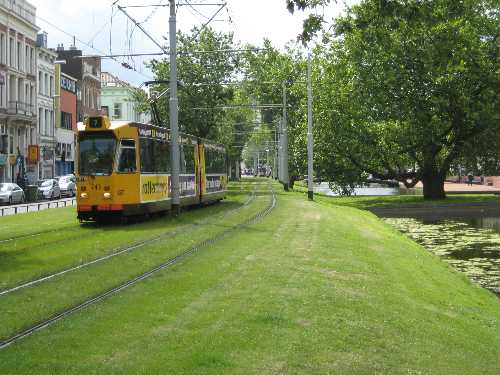
Tram, Rotterdam |
were connected not only by the train tracks, but also by a heavily used bike trail running alongside these tracks. Underpinning this intricate collage was the infrastructure to keep the Netherlands from flooding (roughly 25% of the land area and 60% of the population reside below sea level). Rather than having large, homogeneous sections of built environment that suffer from a debilitating indifference to adjacent developments and conditions, the Netherlands seem to work to efficiently provide goods and services at a local level through intelligent and efficient planning on a large, yet unobtrusive scale.
I arrived in Rotterdam and made plans to meet a friend who had recently moved to the city to begin work at the Office for Metropolitan Architecture. Making my way towards the tram station, not only did I admire the sleek, modern tram cars themselves, but also the way in which Rotterdam was able to integrate these trams with bikes, motor vehicles, buses and nature in a seamless fashion. I still cannot get over how in many parts of the city grass has been intentionally planted between the tram rails.
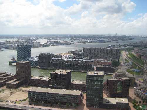
During my days in Rotterdam, I spent much time exploring the waterfront and working port of the city, and was continually impressed by the way in which conflicting urban conditions and functions seemed to work harmoniously with one another, even when in extremely close proximity to one another. Again I thought of the many trips that I have taken between New York and Philadelphia, particularly the stretch through the Newark-Elizabeth Marine Terminal. Although this area is home to
 |
|
Port, Rotterdam |
busiest port facility and transportation break on the East Coast of the U.S., abandoned shipping infrastructure litters the marsh land and the area falls far short of Rotterdam’s port in terms if respecting and enhancing other urban functions.
Observation 2: Walking from Alexanderplatz to Kreuzberg.
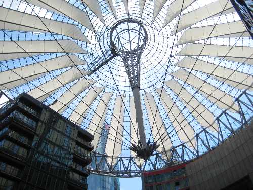
During my first day in Berlin I hit some of the “must-sees” on my own; Alexanderplatz, Potsdamer Platz and Sony’s new European headquarters designed by Helmut
 |
|
Sony Headquarters, Berlin |
Jahn. I saw the Tiergarten, the Reichstag, Brandenburg Gate, and the Bauhaus Museum.
I ate the typical bratwurst, currywurst, and fries with 40+ topping options. On the morning of my second day in Berlin, a Moroccan girl who was also traveling alone convinced me to go on an “alternative” tour with her. Not one who is usually eager for a guided tour, I made her show me the flyer that she had found in a bar near our hostel. “Alternative Berlin” it read, “if museums, lines, and a strict schedule are what you want, this is not the tour for you”. I was sold.
A motley crew of travelers assembled early in the morning at a brat stand near Alexanderplatz, and what followed was a day-long ramble to the city’s less frequently seen marvels at the freehand design of our not-so-sober guide who cared deeply that we all experience the “real” Berlin. Although I cannot go into detail about all of the stops that we made that day to abandoned Nazi bunkers and off-beat Shawarma stands, our visit to the Turkish neighborhood of Kreuzberg on the Eastern edge of the city was particularly striking.
As Berlin began to industrialize in the 1860’s, Kreuzberg became the home to the laboring masses as well as the site of many factories. Because Kreuzberg had one of the highest population densities in all of Europe and housed the industrial work force of Nazi Germany, it was a frequent target of Allied Force bombardments. After the war, rents were controlled by law, which prevented rampant speculation, but simultaneously kept housing quality low. As a result, this neighborhood quickly became a magnet for those living on a tight budget: artists, young people, and more importantly, immigrants. Ties between Turkey and Germany did not completely unravel at the end of the war– today Berlin is home to the largest population of Turks outside of Turkey.
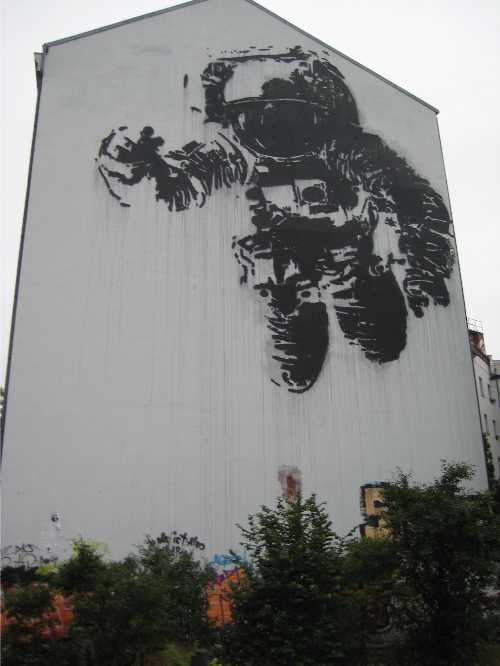 |
|
Mural, Berlin |
It is easy to see how the Kreuzberg of today was and still is the result of three factors; massive wartime urban destruction, working class and industrial mentality, and immigrant influence. Although there has been large-scale development in Kreuzberg over the decades, large swaths of vacant land still abound. But unlike much of the vacant land that exists in most post-war American cities, these spaces have been reclaimed by neighborhood residents in order to serve a greater public good. Unsanctioned parks have developed in the spaces that very easily could have remained voids in the urban fabric. Instead of being dominated by overgrown lots that consistently remind passers-by of wartime destruction, Kreuzberg is home to countless communally maintained sculpture gardens, soccer fields, and skate parks, many of which are accompanied by bold murals.
One day/night I found myself at a place known as Cassiopeia, the site of a destroyed factory complex along the Spree River. At Casseopeia, I sat with locals to admire the skill of youths in the skate park, watched a mural artist do her thing in a bombed out factory and an outdoor screening of a film for 1 Euro, bought 12” vinyl albums of Paul Robeson and a Brazilian funk group from a weekly flea market, listened to a DJ spin Turkish and German hip hop, and gorged on Turkish food and German drink. Again, I was struck by the way in which the neighborhood had reclaimed a devastated space and transformed it into a haven of eclectic cultural, creativity and recreation
Rotterdam and Berlin during the War.
.jpg) |
On May 14th of 1940, Rotterdam buckled under heavy German Aerial bombardment, in an attack now known as the Rotterdam Blitz. Hoping to support German ground troops and force a Dutch surrender, the Luftwaffe engaged in heavy carpet bombing of downtown Rotterdam. Although the aerial forces did have primitive techniques to employ “precision” bombing (a deliberate attempt to shell only military targets), the bombers distributed their payload over military and non-military targets alike to demonstrate to the Dutch the potential fate of Amsterdam and The Hague should Dutch forces continue to resist German occupation. After the dust had settled from the Blitz, official records tallied the destruction of 25,000 homes, 24 churches, 2,500 stores, 775 warehouses, and 60 schools.
Although no single mission brought similar amounts of destruction to Berlin, over 350 air raids throughout the war decimated neighborhoods such as Kreuzberg. Like Rotterdam, the infrastructure that was destroyed was not just military depots and airfields, but also the bricks and mortar backbone of civilian life, work, worship, and recreation. And in the final and fleeting days of the Third Reich’s control of Berlin, Hitler ordered his retreating forces to destroy the best of the remaining buildings so as to prevent new occupiers from using the city built by the hands of Germans.
I mention these horrifying events not to comment on man’s despicable practice of Total Warfare, but rather to highlight how these cities were literally and figuratively diminished to rubble in the relatively
 |
|
Church, Berlin |
recent past. It is remarkable how these two cities have rebounded. As far as I can observe, Rotterdam has almost erased any physical evidence of the bombings. There are no abandoned factories with mortar holes still in the walls. Perhaps the only reminder of the destruction is the clean and deliberate feel of the entire city. Although Rotterdam dates back to the 1300’s and experienced rapid growth in the 1800’s with the expansion of the port, I did not sense Rotterdam’s “oldness” when exploring the city. Downtown Rotterdam is extremely modern in form and function on both a micro and macro scale. I cannot help but speculate that this comprehensive modernity would not have been achieved if the city had not been so thoroughly razed by German forces. The loss of life and prewar architectural gems is an absolute travesty, but the city makers responsible for the present Rotterdam deserve serious commendation.
Berlin on the other hand, although having its fair share of modern and impressive development, has many visible reminders of the violent past. The Berlin Wall at the East Side Gallery is still intact, and serves as an active memorial. The many parcels in Kreuzberg that are now “unofficial” parks clearly exist because buildings on these sites were destroyed and not reconstructed. Rather than leave these unused lots as painful reminders of the war, Kreuzberg residents have reclaimed them and creatively put them into active use. In a sense, what I see here is an embracing of the destruction in order to create new urban form and function regardless of the fact that large scale construction did not happen. Although not in Kreuzberg, the Kaiser Wilhelm Memorial very much embodies this idea of embracing the destruction in order to create.
To be sure, the post-war history of these two cities has been the driving force behind this difference. Rotterdam’s recovery was aided by the financial support of the “victors” and by its continued role as the most active shipping port in Europe. Berlin unfortunately, as we all know, became the site of an extended political battle- the Berlin Wall split Berlin in two until 1990. That being said, Berlin is in the middle of a serious flood of large-scale and modern construction projects in certain sections such as the Hauptbahnhof train station (the largest and most active station in Europe), Potsdamer Platz and Alexanderplatz. Although the economic climate at the moment is not ideal for large scale development, Berlin will likely continue to be a proving ground for modern design in the coming years.
Final Remarks
 |
Back in Philadelphia some time after my trip, I continued to wrestle with this idea of creation through destruction, or rather the act of creating in a post-destruction climate. I returned to Mike Davis’ text, and was pleased to find that he was able make a connection between what I see in Philadelphia (neighborhoods suffering from wide-spread abandonment), and the situation facing a war-ravaged Europe during and after the war;
“In most of Western Europe . . . urban-industrial brownfields, like the bombsites that preceded them, are eventually recycled into productive use, often after systematic surveys and planning. This is not the case in the United States, where . . . urban dereliction had become the moral and natural-historical equivalent of war. In 1940-41, the Heinkel and Junkers bombers of the Luftwaffe destroyed 350,000 dwellings and unhoused a million Londoners. In the 1970’s, an equally savage “blitz” of landlord disinvestment, bank redlining, and federal ‘benign neglect’ led to the destruction of 294,000 housing units in New York City alone.”
I am not prepared right here and right now to propose plans to ameliorate conditions of urban dereliction that persist in many of our cities. Nevertheless, what is clear to me right now is that there exists a large variety of ways in which post-trauma cities can again serve the needs of its inhabitants and foster social interaction. Not all efforts have to be as grand in scale as Potsdamer Platz. From what I observed, it is places like Casseopeia and the Kreuzberg infill parks that support the social interaction that is especially important in cities trying to heal from urban dereliction, weather that dereliction is caused by a violent war or veiled behind economic and political abandonment.
|
|
|
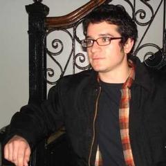
Ian Duncan Mactavish, Columbia University, USA; Open Public Urban Spaces 2008 Annual Conference, Stavanger, Norway
|
|


.jpg)


